LAStools
The LAStools Software Suite is a collection of 52 highly efficient, batch-scriptable, multicore command-line tools for processing point clouds. The tools can also be run via a native GUI (laslook) and are available as toolboxes (QGIS, ArcGIS Pro, FME, Erdas). The software combines robust algorithms with efficient I/O, making LAStools the fastest & most memory-efficient solution for batch-scripted multicore LiDAR processing. It can turn billions of points into valuable products at blazing speed & with low memory requirements. The ability to script the modules makes the software ideal for use on web servers or in the cloud. LAStools has deep market-penetration and is widely used across industry, governments, research labs & educational institutions around the globe.
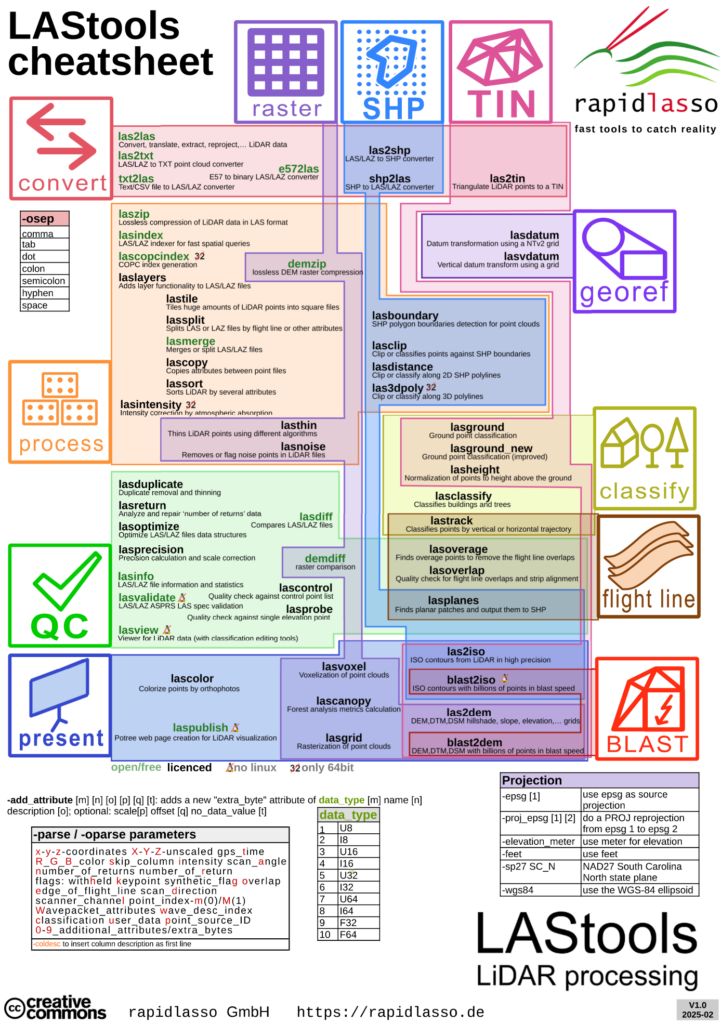
Overview of all LAStools
DATA COMPRESSION
- laszip – Lossless compression of LiDAR data in LAS format. <open source>
- demzip – Lossless compression of DEM data. <free>
DATA CONVERSION (Import / Export)
- las2txt – Converts LiDAR from LAS/LAZ/BIN/ASCII format into ASCII format. <open source>
- txt2las – Converts LiDAR data from ASCII text formats to binary LAS/LAZ/BIN format. <open source>
- las2las – Extract first/last returns, reprojects, subsamples, translates,… LiDAR in LAS/LAZ/BIN/ASCII format. <open source>
- e572las – Converts 3D point files in E57 format to binary LAS/LAZ format. <open source>
- las2shp – Converts LiDAR from LAS/LAZ/BIN/ASCII format into ESRI Shapefile format. <licensed>
- shp2las – Converts ESRI Shapefiles with Points or MultiPoints to LAS/LAZ/BIN/TXT files. <licensed>
CLASSIFICATION & FILTERING
- lasground_new – Extracts the bare-earth from LiDAR by classifying ground points (improved version). <licensed>
- lasground – Extracts the bare-earth from LiDAR by classifying ground points. <licensed>
- lasclassify – Finds buildings and trees in airborne LiDAR point clouds. <licensed>
- lastrack – Classifies LiDAR point based on vertical or horizontal trajectory. <licensed>
- lasthin – Thins LiDAR points using the lowest, highest or a random point per grid set. <licensed>
- lasthin3d – Thins LiDAR points by 3d voxels using a certain point per voxel. <licensed>
- sonarnoiseblaster – Streaming cleaning of massive SONAR point clouds from multi-beam echosounders. <free>
DSM/DTM GENERATION & PRODUCTS
- las2dem_new – Fast DSM/DTM with spike-free operation to hillshade, slope, elevation, RGB or false color grid rasterization. <licensed>
- las2dem – Rasters LiDAR (via a temporary TIN) to hillshade, slope, elevation, RGB or false color grid. <licensed>
- las2iso – Extracts, optionally simplified, elevation contours from LiDAR (via a temporary TIN). <licensed>
- lasgrid – Rasterizes huge LiDAR collections into grids by elevation, intensity, …. <licensed>
- lasheight – Computes for each LiDAR point its height above the ground. <licensed>
- lascanopy – Computes many different plot or raster metrics for forest analysis. <licensed>
- lasvoxel – Computes various voxelizations for LiDAR point clouds. <licensed>
- demdiff – Compares rasters in ASC, BIL, TIF, IMG, RasterLAZ formats and reports differences. <free>
- las2tin – Triangulates the LiDAR points of a LAS/LAZ/BIN/ASCII file into a TIN. <licensed>
- lasplanes – Finds sufficiently planar patches of LAS/LAZ points fulfilling several criteria and output them in SHP or PEF format. <licensed>
- lascolor – Colors LiDAR points using RGB values from an orthophoto. <licensed>
- blast2dem – Rasters billions of LiDAR points via a streaming TIN to elevation, intensity, slope or RGB grid. <licensed>
- blast2iso – Contours billions of LiDAR points via a streaming TIN to isolineas in KML or SHP format. <licensed>
PREPROCESSING
- lasindex – Creates a spatial index (*.LAX) for fast spatial queries. <open source>
- laslayers – Adds layer functionality to LAS/LAZ files. <licensed>
- lasmerge – Merges several LiDAR files into one (or splits them into several parts). <open source>
- lasoverage – Finds and flags overage points to remove the flightline overlaps from an airborne LiDAR collect. <licensed>
- lasboundary – Computes the exact boundary polygon for massive amounts of LiDAR points. <licensed>
- lasclip – Clips or classifies LiDAR points against poligonal building footprints/swath boundaries. <licensed>
- lasoptimize – Optimize, compress and spatially index LiDAR files before distribution. <free>
- lassort – Sorts LiDAR by gps_time, point_source, or into spatial proximity via space filling curve. <licensed>
- lasduplicate – Removes duplicate LiDAR points with identical x and y coordinates (and optionally, z). <licensed>
- lastile – Tiles huge amounts of LiDAR points from LAS/LAZ/BIN/ASCII format into square files. <licensed>
- lassplit – Splits LAS or LAZ files into multiple files by flightline or other attributes. <licensed>
- lasnoise – Removes or flag isolated noise points in LiDAR files. <licensed>
- lascopy – Copies selected point attributes from a reference file to a target file. <licensed>
- lasdatum – Shift LiDAR points via a NTv2 grid transformation. <licensed>
- lasdiff – Compares two LAS/LAZ files and reports whether and where they are identical or different. <open source>
- lasdistance – Classifies, flags, or remove points within a specified distance of polygonal segments. <licensed>
- lasprecision – Finds the actual precision of LiDAR points and allows to correct the scaling if necessary. <open source>
- lasvdatum – Transforms LiDAR from ellipsoidal to orthometric elevations using a grid. <licensed>
- las3dpoly – Modifies points within a certain distance of polylines. <licensed>
- lasintensity – Corrects the intensity attenuation due to atmospheric absorption. <licensed>
- lascopcindex – Creates a COPC *.laz file for a given set of *.las or *.laz files. <open source>
QUALITY CONTROL & INFORMATION
- lasinfo – Extracts metadata information and additional information from a LAZ/LAS file. <open source>
- lasoverlap – Quality check for LiDAR flightline overlaps and horizontal/vertical alignments. <licensed>
- lasreturn – Reports geometric returns statistics and repairs ‘number of returns’ field based on GPS time. <licensed>
- lascontrol – Quality check of LiDAR elevation against a list of control points. <licensed>
- lasprobe – Probes the elevation of the LIDAR for a given x and y location and reports it to a text file or to stdout. <licensed>
- lasvalidate – Determine if LAS files are conform to the ASPRS LAS specification. <open source>
- geotiffinfo – Informs about all header fields in a GeoTIFF file. <free>
- wktformat – Formats a WKT/WKT2 string. <free>
VISUALIZATION
- laslook – New GUI & viewer for LAStools: 3D visualization. Central library of all functions. Direct access to header files. Integrated execution console with simple testing functions tracking script history and performance. <free>
- lasview – Viewer for LiDAR data (includes manual classification editing tools). <free>
- laspublish – Creates a Web page for online viewing and download of LiDAR using Potree. <licensed>