Huaibo Mu (recipient of three LASmoons)
Environmental Mapping, Department of Geography
University College London (UCL), UK
Background:
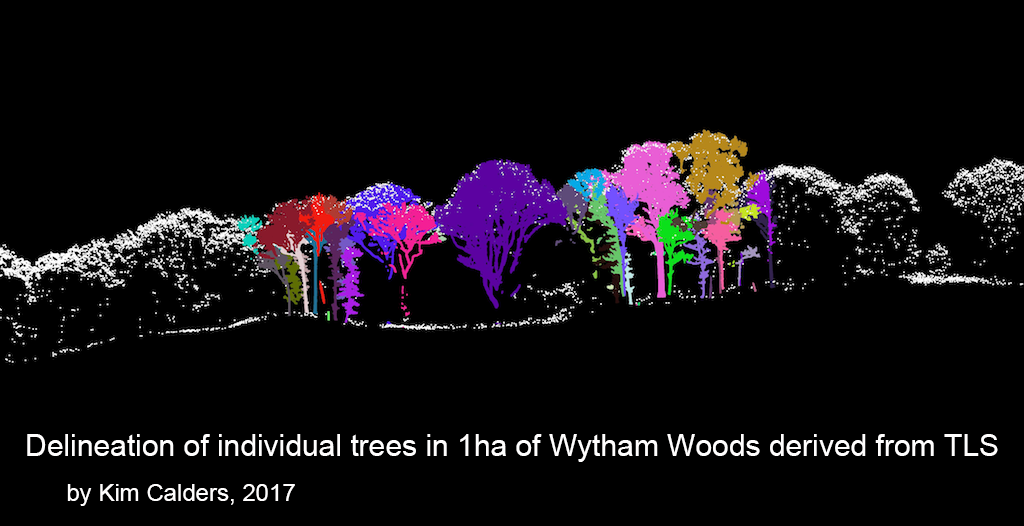
This study is a part of the EU-funded Metrology for Earth Observation and Climate project (MetEOC-2). It aims to combine terrestrial and airborne LiDAR data to estimate biomass and allometry for woodland trees in the UK. Airborne LiDAR can capture large amounts of data over large areas, while terrestrial LiDAR can provide much more details of high quality in specific areas. The biomass and allometry for individual specific tree species in 1 ha of Wytham Woods located about 5km north west of the University of Oxford, UK are estimated by combining both airborne and terrestrial LiDAR. Then the bias will be evaluated when estimation are applied on different levels: terrestrial LiDAR level, tree level, and area level. The goal are better insights and a controllable error range in the bias of biomass and allometry estimates for woodland trees based on airborne LiDAR.
Goal:
The study aims to find the suitable parameters of allometric equations for different specific species and establish the relationship between the tree height and stem diameter and crown diameter to be able to estimate the above ground biomass using airborne LiDAR. The biomass estimates under different levels are then compared to evaluate the bias and for the total 6ha of Wytham Woods for calibration and validation. Finally the results are to be applied to other woodlands in the UK. The LiDAR processing tasks for which LAStools are used mainly center around the creation of suitable a Canopy Height Model (CHM) from the airborne LiDAR.
Data:
+ Airborne LiDAR data produced by Professor David Coomes (University of Cambridge) with Airborne Research and Survey Facility (ARSF) Project code of RG13_08 in June 2014. The average point density is about 5.886 per m^2.
+ Terrestrial LiDAR data collected by UCL’s team leader by Dr. Mat Disney and Dr. Kim Calders in order to develop very detailed 3D models of the trees.
+ Fieldwork from the project „Initial Results from Establishment of a Long-term Broadleaf Monitoring Plot at Wytham Woods, Oxford, UK“ by Butt et al. (2009).
LAStools processing:
1) check LiDAR quality as described in these videos and articles [lasinfo, lasvalidate, lasoverlap, lasgrid, las2dem]
2) classify into ground and non-ground points using tile-based processing [lastile, lasground]
3) generate a Digital Terrain Model (DTM) [las2dem]
4) compute height of points and delete points higher than maximum tree height obtained from terrestrial LiDAR [lasheight]
5) convert points into disks with 10 cm diameter to conservatively account for laser beam width [lasthin]
6) generate spike-free Digital Surface Model (DSM) based on algorithm by Khosravipour et al. (2016) [las2dem]
7) create Canopy Height Model (CHM) by subtracting DTM from spike-free DSM [lasheight].
References:
Butt, N., Campbell, G., Malhi, Y., Morecroft, M., Fenn, K., & Thomas, M. (2009). Initial results from establishment of a long-term broadleaf monitoring plot at Wytham Woods, Oxford, UK. University Oxford, Oxford, UK, Rep.
Khosravipour, A., Skidmore, A.K., Isenburg, M., Wang, T.J., Hussin, Y.A., (2014). Generating pit-free Canopy Height Models from Airborne LiDAR. PE&RS = Photogrammetric Engineering and Remote Sensing 80, 863-872.
Khosravipour, A., Skidmore, A.K., Isenburg, M. and Wang, T.J. (2015) Development of an algorithm to generate pit-free Digital Surface Models from LiDAR, Proceedings of SilviLaser 2015, pp. 247-249, September 2015.
Khosravipour, A., Skidmore, A.K., Isenburg, M (2016) Generating spike-free Digital Surface Models using raw LiDAR point clouds: a new approach for forestry applications, (journal manuscript under review).

