Raja Ram Aryal (recipient of three LASmoons)
Photogrammetry and Geoinformatics
University of Applied Sciences Stuttgart, GERMANY
Background:
Obtaining LiDAR-derived products like Digital Terrain Models (DTMs), Digital Surface Models (DSMs) and Canopy Height Models (CHMs) is a challenging task in steep forest areas. The Bavarian Forest National Park is an example of a steep terrain in central Europe.The national park mainly consists of alluvial spruce forest (700-900m altitude range), mixed mountain forest dominated by spruce, beech and fir (700-1150m) and high spruce forests (1150-1200m).
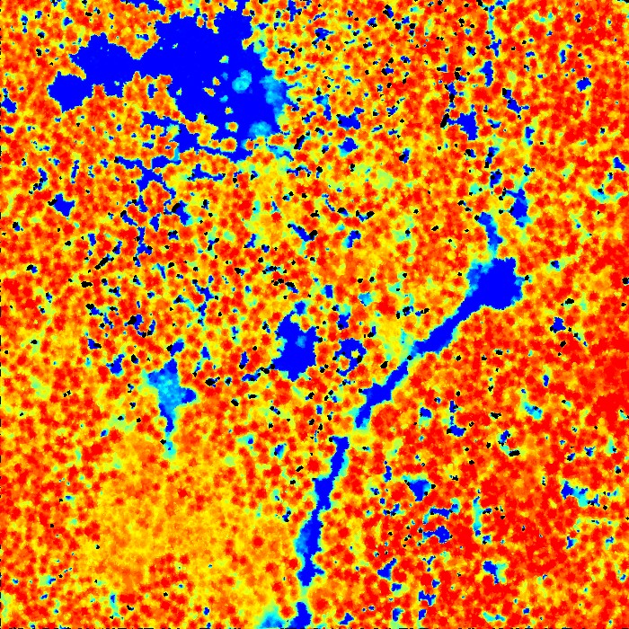
Leaf-on and leaf-off LiDAR data acquisition affects the quality of the DTM needed for deriving a CHM. Different algorithms have been developed for separating ground points from non-ground points in steep forest terrains. The accuracy of such algorithms and their effect on derived forest attributes needs to be assessed. Furthermore, for various system-related or post processing reasons there are often „data pits“ in the CHM. The „pit-free algorithm“ developed by Khosravipour et al.(2014) that can be implemented with LAStools is currently the state-of-art for producing high-quality CHMs for better tree top detection. Further work is needed to investigate which other forest structure attributes can be derived with higher accuracy from a pit-free CHM than from a standard CHM.
Goal:
This study will focus on (1) evaluating the performance of a different ground classification algorithms across habitat types and topographical factors to assess their applicability for forest management in steep areas, and (2) comparing the accuracy of various forest parameter retrieved from pit-free versus standard CHMs incorporating the most accurate DTM derived from (1). To accomplish goal (1), DTMs will be produced by means of a set of commonly-used methods (REIN, MGF and TIN algorithms), which are then compared against precisely-recorded reference transect ground data, as well as across habitat types and topographical attributes. To accomplish goal (2) pit-free and standard CHMs will be derived and compared for various spatial plot-based models of forest structural attributes. The models will be cross-validated against the available forest inventory data.

Data:
+ Two acquisitions of small footprint discrete return LiDAR data and Full wave-form are conducted in the study area. The full wave form LiDAR data has been captured in 2012 at the leaf-on condition. A two pulse discrete returns LiDAR data was captured in 2009 by the “Bayrisches Landesvermessungsamt” at the leaf-off with a lower point density about 4-5 points per m².
+ The ground data are transect- and systematically recorded plot designs. The transect data (ca. 300 sub plots) is constrained to ecological gradients in some parts of the park, whereas the systematic grid data (ca. 120 plots) is distributed throughout the entire national park.

LAStools processing:
1) create square tiles with edge length of 1000 m and a 25 m buffer to avoid edge artifacts [lastile]
2) classify point clouds into ground and non-ground [lasground]
3) generate DTMs and DSMs [las2dem]
4).produce height normalized tiles [lasheight]
5) compute plot metrics for forest structure from height normalized tiles [lascanopy]
6) generate a Canopy Height Model (CHM) using the pit-free method of Khosravipour et al. (2014) with the workflow described here [lasthin, las2dem, lasgrid]
Reference:
Heurich, M., Fischer, F., Knörzer, O., Krzystek, P. 2008. Assessment of Digital Terrain Models (DTM) from data gathered with airborne laser scanning in temperate European beech (Fagus sylvatica) and Norway spruce (Picea abies) forests. Photogrammetrie, Fernerkundung, Geoinformation 6/2008: 473-488.
Khosravipour, A., Skidmore, A.K., Isenburg, M., Wang, T.J., Hussin, Y.A., 2014. Generating pit-free Canopy Height Models from Airborne LiDAR. PE&RS = Photogrammetric Engineering and Remote Sensing 80, 863-872.
Kobler, A., Pfeifer, N., PeterOgrinc, Todorovski, L., Oštir, K. and Džeroski, S. 2007: Repetitive interpolation: A robust algorithm for DTM generation from aerial laser scanner data in forested terrain. Remote Sensing of Environment 108, 9-23.
Latifi, H., Heurich, M., Hartig, F., Müller, J., Krzystek, P., Jehl, H., Dech, S., 2015, Estimating over- and understorey canopy density of temperate mixed stands by airborne LiDAR data. Forestry (Article in Press). DOI. 10.1093/forestry/cpv032
Latifi, H., Fassnacht, F. E., Müller, J., Tharani, A., Dech, S., and Heurich, M. (2015) Forest inventories by LiDAR data: A comparison of single tree segmentation and metric-based methods for inventories of a heterogeneous temperate forest, International Journal of Applied Earth Observation and Geoinformation 42: 162-174.
Meng, X.; Wang, L.; Silván-Cárdenas, J.L.; Currit, N. A multi-directional ground filtering algorithm for airborne LiDAR. ISPRS J. Photogramm. Remote Sens. 2009, 64, 117-124.
