One of our most popular (and controversial) blog articles was „Can You Copyright LiDAR„. It was written after we saw the then chief executive director at CyArk commenting “Sweeeet use of CyArk data” on an article describing the creation of a sugary fudge replica of Guatemala’s Tikal temple promoting a series of sugars by multinational agribusiness Tate & Lyle. Yet just a few months earlier our CEO’s university was instructed to take down his Web pages that – using the same data set – were demonstrating how to realize efficient 3D content delivery across the Web. CyArk told university administrators in an email that he was “[…] hosting unauthorized content from CyArk […]”. The full story is here.
Back then, the digital preservation strategy of CyArk was to keep their archaeological scans safe through their partnership with Iron Mountain. In the comment section of „Can You Copyright LiDAR“ you can find several entries that are critical of this approach. But that was five years ago. Earlier this year and just after Google removed the „Don’t be Evil“ mantra from their code of conduct, CyArk stepped up to take it over and completely changed their tight data control policies. Through their „Open Heritage initiative“ CyArk released for the first time their raw LiDAR and imagery with an open license. Here in their own words:
In 2018, CyArk launched the Open Heritage initiative, a
collaboration with Google Arts and Culture to make available
our archive to a broader audience. This was the first time
CyArk has made available primary data sets, including lidar
scans, photogrammetric imagery and corresponding metadata
in a standardized format on a self-serve platform. We are
committed to opening up our archive further as we collect
new data and publishing existing projects where permissions
allow. The data is made available for education, research
and other non-commercial uses via a a Creative Commons
Attribution-NonCommercial 4.0 International License.
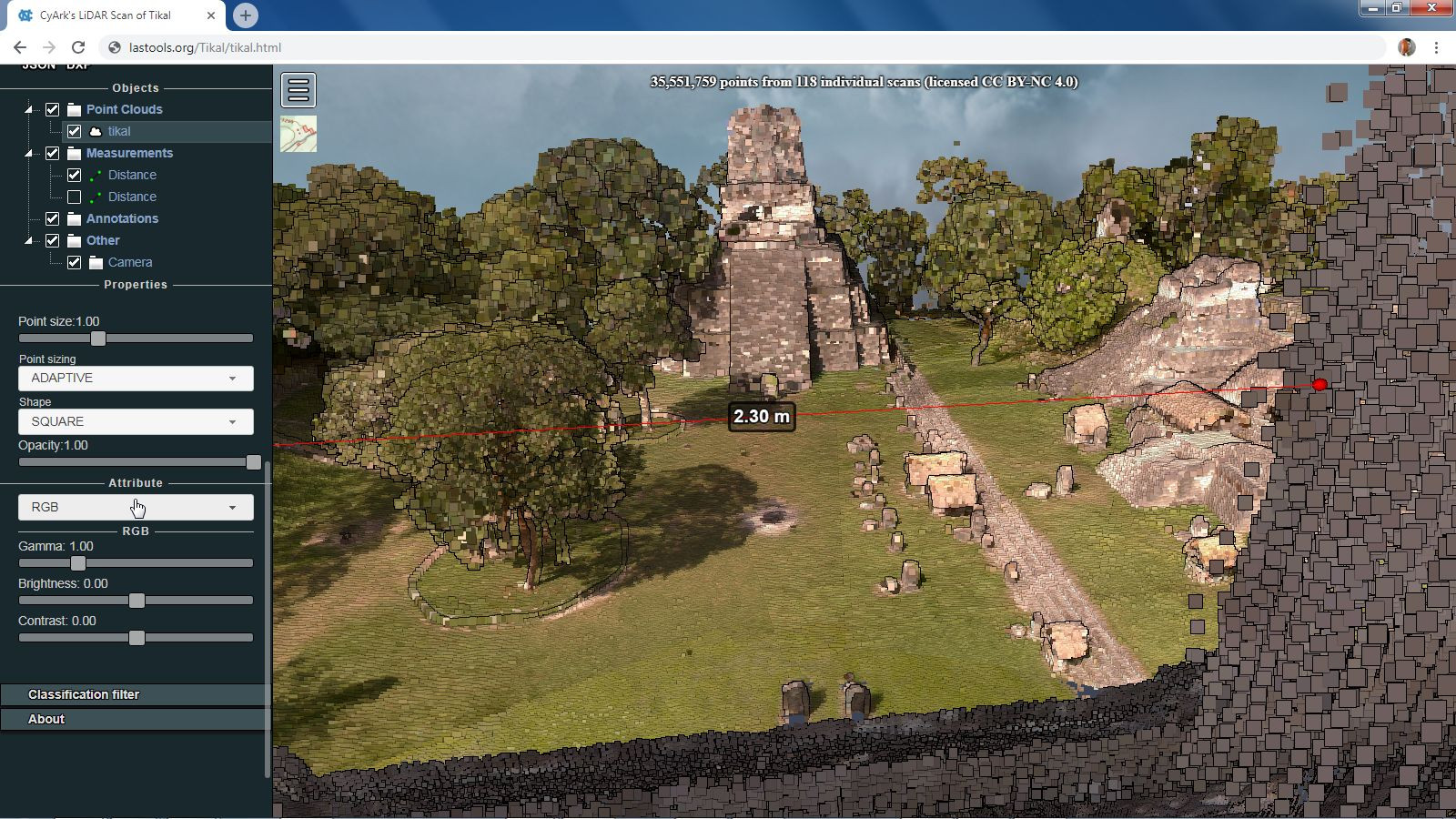
This is a HUGE change from the situation in 2013 that resulted in the deletion of our CEO’s Web pages. So we went to download Guatemala’s Tikal temple – the one that got him into trouble back then. It is provided as a single E57 file called ‚Tikal.e57‘ with a size of 1074 MB that contains 35,551,759 points in 118 individual scan positions. Using the e572las.exe tool that is part of LAStools we converted this into a single LAZ file ‚Tikal.laz‘ with a size of 164 MB.
C:\LAStools\bin>e572las -i c:\data\Tikal\Tikal.e57 ^
                        -o c:\data\Tikal\Tikal.laz
We were not able to find information about the Coordinate Reference System (CRS), but after looking at the coordinate bounding box (see lasinfo report at the end of the article) and the set of projections covering Guatemala, one can make an educated guess that it might be UTM 16 north. Generating a false-colored highest-return 0.5 meter raster with lasgrid and loading it into Google Earth quickly confirms that this is correct.
lasgrid -i c:\data\Tikal\Tikal.laz ^
        -step 0.5 ^
        -highest ^
        -false ^
        -utm 16north ^
        -odix _elev -opng


Now we can laspublish the file with the command line below to create an interactive 3D Web portal using Potree. Unlike five years ago we should now be permitted to create an online portal without the headaches of last time. The CC BY-NC 4.0 license allows to copy and redistribute the material in any medium or format.
laspublish -i c:\data\Tikal\Tikal.laz ^
           -rgb ^
           -utm 16north ^
           -o tikal.html ^
           -title "CyArk's LiDAR Scan of Tikal" ^
           -description "35,551,759 points from 118 individual scans (licensed CC BY-NC 4.0)" ^
           -odir C:\data\Tikal\Tikal -olaz ^
           -overwrite
Below are two screenshots of the online portal that we have just created including some quick distance measurements. This is amazing data. Wow!

We congratulate CyArk to their new Open Heritage initiative and thank them for providing easy access to the Tikal temple LiDAR scans as open data with a useful Creative Commons Attribution-NonCommercial 4.0 International license. Thank you, CyArk, for your contribution to open data and open science. Kudos!
C:\LAStools\bin>lasinfo -i c:\data\Tikal\Tikal.laz
lasinfo (181119) report for 'c:\data\Tikal\Tikal.laz'
reporting all LAS header entries:
  file signature:             'LASF'
  file source ID:             0
  global_encoding:            0
  project ID GUID data 1-4:   00000000-0000-0000-0000-000000000000
  version major.minor:        1.2
  system identifier:          'LAStools (c) by Martin Isenburg'
  generating software:        'e572las.exe (version 180919)'
  file creation day/year:     0/0
  header size:                227
  offset to point data:       227
  number var. length records: 0
  point data format:          2
  point data record length:   26
  number of point records:    35551759
  number of points by return: 35551759 0 0 0 0
  scale factor x y z:         0.001 0.001 0.001
  offset x y z:               220000 1900000 0
  min x y z:                  220854.951 1905881.781 291.967
  max x y z:                  221115.921 1906154.829 341.540
LASzip compression (version 3.2r4 c2 50000): POINT10 2 RGB12 2
reporting minimum and maximum for all LAS point record entries ...
  X              854951    1115921
  Y             5881781    6154829
  Z              291967     341540
  intensity       24832      44800
  return_number       1          1
  number_of_returns   1          1
  edge_of_flight_line 0          0
  scan_direction_flag 0          0
  classification      0          0
  scan_angle_rank     0          0
  user_data           0          0
  point_source_ID     1        118
  Color R 0 65280
        G 0 65280
        B 0 65280
number of first returns:        35551759
number of intermediate returns: 0
number of last returns:         35551759
number of single returns:       35551759
overview over number of returns of given pulse: 35551759 0 0 0 0 0 0
histogram of classification of points:
        35551759  never classified (0)
Martin,
This is indeed good news. I have downloaded Pompeii, and then went to check on the license for e57las (you didn’t have any comments about that choice of format, and I might have suggested they would do better with las, but beggars cannot be choosers, too much). I cannot find e57las listed on the license page. What is its status?
E57 is a good distribution format as it contains the 118 individual scans in their original local coordinate system with rotation and translation matrices. A clever user could try to improve alignment further. That would be impossible if stored as LAS/LAZ. So in a sense the E57 captures the raw LiDAR better. It really is well suited for multiple terrestrial scan positions. Better than LAS/LAZ.
On which license page are you missing e572las? It’s freeware and part of the LAStools distribution.
Pingback: Can you copyright LiDAR? | rapidlasso GmbH
Hello, I contribute to OpenStreetMap and i love to do 3D tagging in OpenStreetMap. A friend have told me about your data and i was super exited to use is. The problem is the license : the non-commercial use is not compatible with OpenStreetMap. OpenStreetMap can be use for whatever, even commercial use…
Have you any idea about out to solve it ? Data aggregated from LIDAR transformed as flat raster (MNS like) can be used by mapper and maybe you can open it for commercial use easily ?
Well, this is not „my data“ but CyArk’s data you will have to ask CyArk about whether a derivative products (polygons, height rasters, …) generated from the data can be ingested into OSM.