Let’s heat up some sweet, warm and spicy Glögg in celebration! They must have been good boys and girls up there in Sweden. Because „Jultomten“ or simply ”Tomten” – how Sweden’s Santa Clause is called – is assuring a „God Jul“ for all the Swedish LiDAR lovers this Christmas season.
Only a few weeks ago this tweet of ours had (mistakenly) included Sweden in a list of European countries that had released their national LiDAR archives as open data for public reuse over the past six years.
In 6 years of @rapidlasso we saw lots of national #LiDAR in Europe go from #closed to #opendata. Finland, Holland, Denmark, Sweden, England, Estonia, Spain, … but nothing changed in #Asia. Or??? @INSPIRE_EU #INTERGEO2018 #ILMF19 #ACRS2018 #ESRIUC #geobiz https://t.co/ZMYekEmAVJ
— LAStools (@LAStools) November 6, 2018
Turns out we were correct after all. Sweden has just opened their LiDAR data for free and unencumbered download. To get the data simply create a user account and browse to the ftp site for download as shown in the image sequence below.


The released LiDAR data was collected with a density of 1 to 2 pulses per square meter and is distributed in LASzip compressed LAZ tiles of 2500 by 2500 meters. The returns are classified into four classes: ground (2), water (9), low noise (7) and high noise (18). All items that can not be classified as any of the first four classes coded as left unclassified (1). The LAZ files do not contain CRS information, but this can easily be added with horizontal coordinates in SWERED99 TM (EPSG code 3006) and elevations in RH2000 height (EPSG code 5613).
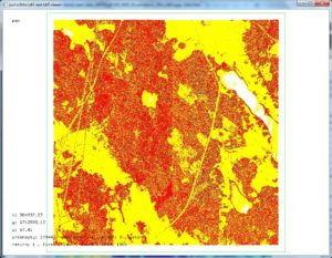
Below a look with lasview at a 5 km by 5 km area that composed of the four tiles ‚18P001_67100_5800_25.laz‚, ‚18P001_67100_5825_25.laz‚, ‚18P001_67125_5800_25.laz‚ and ‚18P001_67125_5825_25.laz‚ with several of the different color modes available.


Some more details: The data was acquired at flying altitude of around 3000 meter with a maximum scan angle of ± 20º and a minimum side overlap of 10% between the flightlines. The laser footprint on ground is below 75 centimeters with slight variation based on the flying altitude. The laser scanning survey was performed with LiDAR instruments that can provide at least three returns from the same pulse. All LiDAR returns are preserved throughout the entire production chain.
The LiDAR data comes with the incredibly Creative Commons – CC0 license, which means that you can use, disseminate, modify and build on the data – even for commercial purposes – without any restrictions. You are free to acknowledge the source when you distribute the data further, but it is not required.
The LiDAR data will eventually cover approximately 75% of Sweden and new point clouds will continuously be added as additional scanning is performed according to the schedule shown below. The survey will be returning to scan every spot again after about 7 years.

Below a lasinfo report for tile ‚18P001_67125_5825_25.laz‚. One noticeable oddity is the distribution of intensities. The histogram across all intensities with bins of size 256 shows two clearly distinct sets of intensities each with their own peak and a void of values between 3000 and 10000.
lasinfo -i 18P001_67125_5825_25.laz -cd -histo intensity 256
reporting all LAS header entries:
  file signature:             'LASF'
  file source ID:             0
  global_encoding:            1
  project ID GUID data 1-4:   00000000-0000-0000-0000-000000000000
  version major.minor:        1.2
  system identifier:          ''
  generating software:        'TerraScan'
  file creation day/year:     303/2018
  header size:                227
  offset to point data:       227
  number var. length records: 0
  point data format:          1
  point data record length:   28
  number of point records:    20670652
  number of points by return: 13947228 4610837 1712043 358397 42147
  scale factor x y z:         0.01 0.01 0.01
  offset x y z:               0 0 0
  min x y z:                  582500.00 6712500.00 64.56
  max x y z:                  584999.99 6714999.99 136.59
LASzip compression (version 3.2r2 c2 50000): POINT10 2 GPSTIME11 2
reporting minimum and maximum for all LAS point record entries ...
  X            58250000   58499999
  Y           671250000  671499999
  Z                6456      13659
  intensity          32      61406
  return_number       1          5
  number_of_returns   1          5
  edge_of_flight_line 0          1
  scan_direction_flag 0          1
  classification      1         18
  scan_angle_rank   -19         19
  user_data           0          1
  point_source_ID  1802       1804
  gps_time 222241082.251248 222676871.876191
number of first returns:        13947228
number of intermediate returns: 2110980
number of last returns:         13952166
number of single returns:       9339722
covered area in square units/kilounits: 5923232/5.92
point density: all returns 3.49 last only 2.36 (per square units)
      spacing: all returns 0.54 last only 0.65 (in units)
overview over number of returns of given pulse: 9339722 5797676 4058773 1263967 210514 0 0
histogram of classification of points:
        10888520  unclassified (1)
         9620725  ground (2)
           22695  noise (7)
          138147  water (9)
             565  Reserved for ASPRS Definition (18)
intensity histogram with bin size 256.000000
  bin [0,256) has 1753205
  bin [256,512) has 3009640
  bin [512,768) has 2240861
  bin [768,1024) has 1970696
  bin [1024,1280) has 1610647
  bin [1280,1536) has 1285858
  bin [1536,1792) has 974475
  bin [1792,2048) has 790480
  bin [2048,2304) has 996926
  bin [2304,2560) has 892755
  bin [2560,2816) has 164142
  bin [2816,3072) has 57367
  bin [3072,3328) has 18
         [void]
  bin [10752,11008) has 589317
  bin [11008,11264) has 3760
  bin [11264,11520) has 99653
  bin [11520,11776) has 778739
  bin [11776,12032) has 1393569
  bin [12032,12288) has 1356850
  bin [12288,12544) has 533202
  bin [12544,12800) has 140223
  bin [12800,13056) has 16195
  bin [13056,13312) has 2319
  bin [13312,13568) has 977
  bin [13568,13824) has 765
  bin [13824,14080) has 648
  bin [14080,14336) has 289
  bin [14336,14592) has 513
  bin [14592,14848) has 383
  bin [14848,15104) has 178
  bin [15104,15360) has 526
  bin [15360,15616) has 108
  bin [15616,15872) has 263
  bin [15872,16128) has 289
  bin [16128,16384) has 69
  bin [16384,16640) has 390
  bin [16640,16896) has 51
  bin [16896,17152) has 186
  bin [17152,17408) has 239
  bin [17408,17664) has 169
  bin [17664,17920) has 58
  bin [17920,18176) has 227
  bin [18176,18432) has 169
  bin [18432,18688) has 40
  bin [18688,18944) has 401
  bin [18944,19200) has 30
  bin [19200,19456) has 411
  bin [19456,19712) has 34
  bin [19712,19968) has 34
  bin [19968,20224) has 398
  bin [20224,20480) has 24
  bin [20480,20736) has 108
  bin [20736,20992) has 267
  bin [20992,21248) has 29
  bin [21248,21504) has 318
  bin [21504,21760) has 26
  bin [21760,22016) has 59
  bin [22016,22272) has 184
  bin [22272,22528) has 52
  bin [22528,22784) has 18
  bin [22784,23040) has 116
  bin [23040,23296) has 55
  bin [23296,23552) has 89
  bin [23552,23808) has 250
  bin [23808,24064) has 24
  bin [24064,24320) has 52
  bin [24320,24576) has 14
  bin [24576,24832) has 29
  bin [24832,25088) has 71
  bin [25088,25344) has 74
  bin [25344,25600) has 2
  bin [25600,25856) has 17
  bin [25856,26112) has 2
  bin [26368,26624) has 9
  bin [26624,26880) has 1
  bin [26880,27136) has 1
  bin [27136,27392) has 1
  bin [27392,27648) has 1
  bin [27648,27904) has 3
  bin [28416,28672) has 2
  bin [29184,29440) has 4
  bin [30720,30976) has 1
  bin [30976,31232) has 2
  bin [31232,31488) has 1
  bin [32512,32768) has 1
  bin [36864,37120) has 1
  bin [58368,58624) has 1
  bin [61184,61440) has 1
  average intensity 3625.2240208968733 for 20670652 element(s)
I visited the site but can’t find an index for the lidar tiles as everything is unsurprisingly in Swedish. Do you know where I can find an index for the tiles?
If you’re still interested: https://www.lantmateriet.se/sv/Kartor-och-geografisk-information/geodataprodukter/
And up in the left corner you can click and choose English for example under „Languages“.
GLHF!