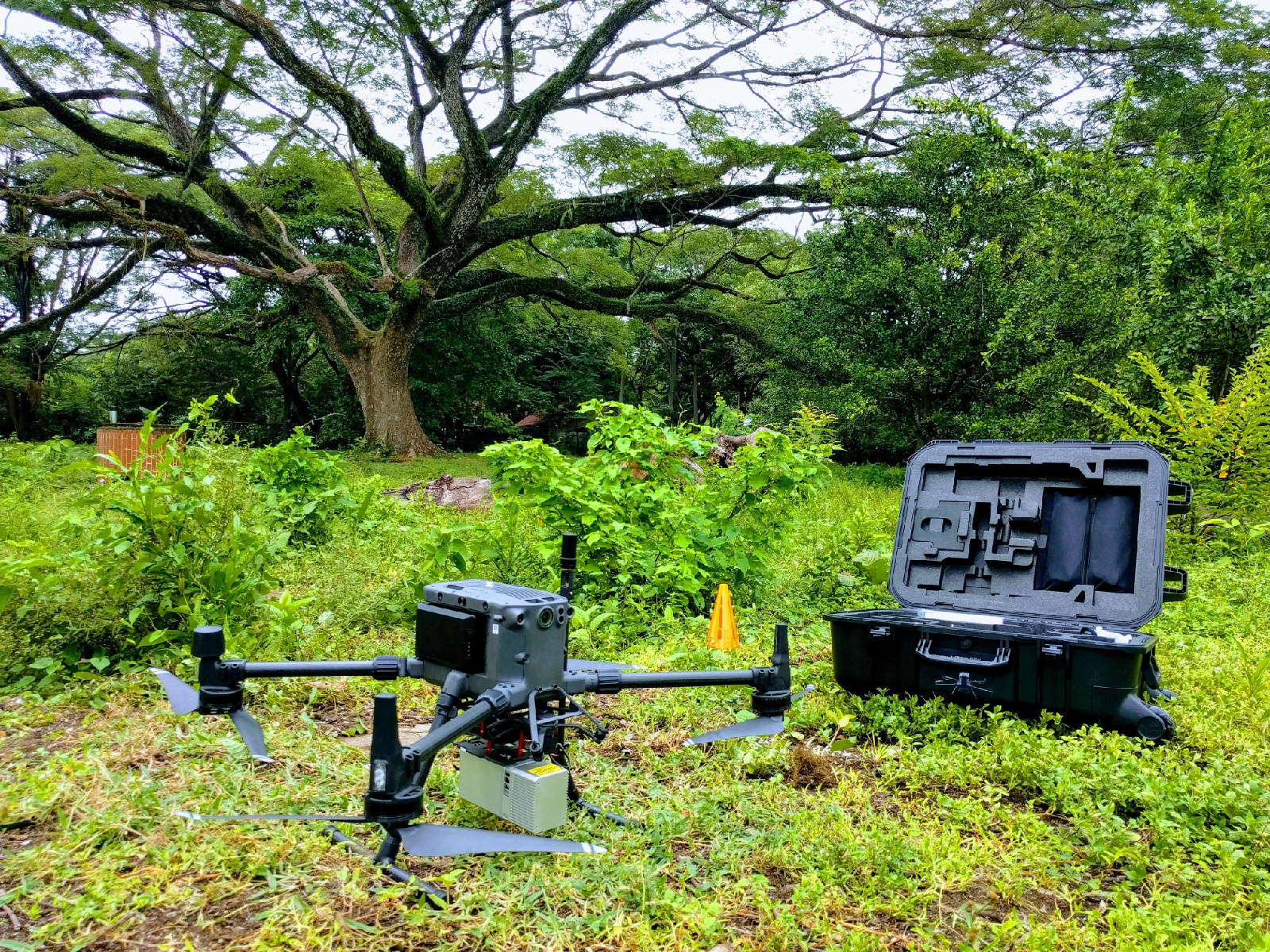
September 11th 2020 seemed like a fitting day to hunt down – with a powerful drone – those who destroy our common good. The latest DJI M300 RTK drone came to visit me in Samara, Guanacaste, Costa Rica and it was carrying the gAirHawk GS-MID40 UAV laser scanning system by Geosun featuring the light-weight Livox Mid 40 LiDAR. The drone is owned and operated by my friends at LiDAR Latinoamerica.


We flew a two-sortie mission covering a destroyed mangrove lagoon that was illegally poisoned, cut-down and filled in with the intention to construct a fancy resort in its place some 25 years ago. For future environmental work I wanted to get a high-resolution baseline scan with detailed topography of the meadow and what now-a-days remains of the mangroves that are part of the adjacent „Rio Lagarto“ estuary. Recently the area was illegally treated with herbicides to eliminate the native herbs and the wild flowers and improve grazing conditions for cattle. Detailed topography can show how the heavy rains have washed these illegal substances into the ocean and further prove that the application of agro-chemicals in this meadow causes harm to marine life.
Here you can see a sequence of video about the LiDAR system, the preparations and the survey flights. Shortly after the flight I obtained the LiDAR from Nelson Mattie, the CEO of LiDAR Latinoamerica and ran the usual quality checks with LAStools.
lasinfo ^
-i Samara\Livox\00_raw_laz\*.laz ^
-histo intensity 16 ^
-histo gps_time 10 ^
-histo z 5 ^
-odir Samara\Livox\01_quality -odix _info -otxt ^
-cores 3
lasgrid ^-i Samara\Livox\00_raw_laz\*.laz ^
-utm 16north ^
-merged ^
-keep_last ^
-step 0.5 ^
-density ^
-false -set_min_max 100 1000 ^
-odir Samara\Livox\01_quality ^
-o density_050cm_100_1000.png
For the density image, lasgrid counts how many last return from all flight lines fall into each 50 cm by 50 cm area, computes the desnity per square meter and maps this number to a color ramp that goes from blue via cyan, yellow and orange to red. The overall density of our survey is in the hundred of laser pulses per square meters with great variations where flight line overlap and at the survey boundary. The start and landing area as well as the place where the first flight ended and the second flight started are the two red spots of maximum density that can easily be picked out.

lasoverlap ^-i Samara\Livox\00_raw_laz\*.laz ^
-utm 16north ^
-merged -faf ^
-step 0.5 ^
-min_diff 0.10 -max_diff 0.25 ^
-elevation -lowest ^
-odir Samara\Livox\01_quality ^
-o overlap_050cm_10cm_25cm.png
For the overlap image lasoverlap counts how many different flight lines overlap each 50 cm by 50 cm area and maps the counter to a color: 1 = blue, 2 = cyan, 3 = yellow, 4 = orange, and 5 of more = red. Here the result suggests that the 27 delivered LAS files do not actually correspond to the logical flight lines but that the files are chopped up in some other way. We will have Andre Jalobeanu from Bayesmap repair this for us later.

For the difference image, lasoverlap finds the maximal vertical difference between the lowest points from all flight lines that overlap for each 50 cm by 50 cm area and maps it to a color. If this difference is less than 10 cm, the area is colored white. Differences of 25 cm or more are colored either red or blue. All open areas such as roads, meadows and rooftops should be white here we definitely have way to much red and blue in the open areas.

There is way too much red and blue in areas that are wide open or on roof tops. We inspect this in further detail by taking a closer look at some of these red and blue areas. For this we first spatially index the strips with lasindex so that area-of-interest queries are accelerated, then load the strips into the GUI of lasview and add the difference image into the background via the overlay option.
lasindex ^\
-i Samara\Livox00_raw_laz\*.laz ^
-tile_size 10 -maximum -100 ^
-cores 3
lasview ^\
-i Samara\Livox00_raw_laz\*.laz ^
-gui

This way is easy to lasview or clip out (with las2las) those areas that look especially troublesome. We do this here for the large condominium „Las Palmeras“ whose roofline and pool provide perfect features to illustrate the misalignment. As you can see in the image sequence below, there is a horizontal shift of up to 1 meter that can be nicely visualized with a cross section drawn perpendicular across the gable of the roof and – due to the inability to get returns from water – in the area without points where the pool is.

condominium „Las Palmeras“ colored by flight line 
picking a line section across the roof 
the horizontal distance between the two gables is around 1 meter 
picking a rectangular section covering the pool 
the three flight lines have noticeable horizontal shifts
The misalignments between flight lines are too big for the data to be useful as is, so we do what we always do when we have this problem: We write an email to Andre Jalobeanu from Bayesmap and ask for help.
After receiving the LAZ files and the trajectory file Andre repaired the misalignment in two steps. The first call to his software stripalign in mode ‚-cut‘ recovered a proper set of flight lines and removed most of the LiDAR points from the moments when the drone was turning. The second call to his software stripalign in mode ‚-align‘ computed the amount of misalignment in this set of flight lines and produced a new set of flight lines with these errors corrected as much as possible. The results are fabulous.
lasmerge ^-i Samara_MID40\*.laz ^-o samaramid40.laz
stripalign ^
-uav -cut ^
-i samaramid40.laz ^
-po Samara_MID40\*.txt -po_parse ntxyzwpk ^
-G2 -cut_dist 50 ^
-O Samara_MID40\cut
stripalign ^
-uav -align ^
-i Samara_MID40\cut\*.laz ^
-po Samara_MID40\*.txt -po_parse ntxyzwpk ^
-A -G2 -full -smap -rmap -sub 2 ^
-O Samara_MID40\corr

error before alignment 
error after alignment
As you can see above, the improvements are incredible. The data seems now sufficiently aligned to be useful for being processed into a number of products. One last thing to do is the removal of spurious scan lines that seem to stem from an unusual movement of the drone, like the beginning or the end of a turn.

We use lasview with option ‚-load_gps_time‘ to determine the GPS time stamps of these spurious scan lines and remove them manually using las2las with option ‚-drop_gps_time_between t1 t2‘ or similar. As the points are ordered in acquisition order, we can simply replay the flight by pressing ‚p‘ and step forward and backward with ’s‘ and ‚S‘.

Once we determined a suitable set of GPS times to remove from a flight lines we first verify our findings once more visually using lasview before actually creating the final cut with las2las.
lasview ^\
-i Samara\Livox02_strips_aligned\samaramid40_c_13_i_13.laz ^
-drop_gps_time_below 283887060 ^
-drop_gps_time_above 283887123 ^
-filtered_transform ^
-set_classification 8 ^
=color_by_classification

las2las ^\
-i Samara\Livox02_strips_aligned\samaramid40_c_13_i_13.laz ^
-drop_gps_time_below 283887060 ^
-drop_gps_time_above 283887123 ^
-odix _cut -olaz
After spending several hours of manually removing these spurious scan lines as well as deciding to remove a few short scan lines in areas of exzessive overlap we have a sufficiently aligned and cleaned data set to start the actual post-processing.
raw flight lines aligned flight lines 
cleaned flight lines
A big „Thank You!“ to Andre Jalobeanu from Bayesmap for his help in aligning the data and to Nelson Mattie from LiDAR Latinoamerica for bringing his fancy drone to Samara. You can download the data here.

You are on the right track.
Pingback: Generating DTM for fluffy Livox MID-40 LiDAR via “median ground” points | rapidlasso GmbH