The empire has not changed their evil ways, despite an encouraging email from ESRI’s founder and president Jack Dangermond in response to the Open Letter by the OSGeo that was delivered to ESRI, OGC, and the ASPRS. Facing an incredible backlash by the LiDAR community over the release of their „LAZ clone“ there was a new hope that unnecessary format fragmention could be avoided by working together within the Point Cloud Domain Working Group of the OGC. In fact only one thing happened: ESRI went silent on the controversy. They temporarily stopped promoting their „LAZ clone“ and focused on locking in more content.

The message of the rebellion has been consistent and clear like in these two videos from the TC meeting of the OGC in Nottingham and the ASPRS side bar in Reno: a roadmap forward to avoid format fragmentation by exploiting the „natural break“ in the format due to LAS 1.4. But there was zero technical contribution from ESRI during the past three PC-DWG meetings of the OGC. The slide sets that bored the audiences in Boulder and in Nottingham were not meant to contribute but merely stalled for time. Recently in Sydney ESRI was awefully quiet, knowing they were doing the exact opposite of what the OGC stands for. And now the empire strikes back.
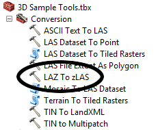
There is a dArc force awakening that threatens the peace within the LiDAR community. ESRI has just released a new tool (see above) that enslaves point clouds by converting them from the open LAZ format to the near-identical but closed „LAZ clone“ that they call „zLAS“ or „Optimized LAS“. This comes just a few months after an entire nation’s LiDAR was enslaved in this proprietary format. We have repeatedly warned about the ramifications of locking up Petabytes of LiDAR data in a closed format that is controlled by a single vendor.
ESRI is one of the largest GIS training organizations. By instructing LiDAR novices to „optimize“ their LiDAR files and pushing LiDAR providers to switch from open LAS or open LAZ to closed zLAS, they effectively destroy the current success of our open formats. ESRI’s command of the GIS market can – little by little – turn their own proprietry format into the dominant way in which LiDAR point clouds are stored. Then we loose our open exchange formats. Hence, ESRI’s proprietary format threatens all that we have achieved with LAS (and LAZ) over the past years: compatible LiDAR data exchange and incredible LiDAR software interoperability.
ESRI is now escalating the LiDAR format wars. Join the rebellion, Jedis: download your lazer sabers and liberate some LiDAR.
This is not an anti-ESRI campaign. For the past three years we have been trying to resolve this situation. We have repeatedly reached out to ESRI to prevent format fragmentation. We have repeatedly offered to create a joint compressed format. We have plead, begged, and bargained for the sake of our LiDAR community and the sake of their ArcGIS user community not to promote a near-identical yet incompatible way for storing massive amounts of point cloud data.