Geoffrey Ower (recipient of three LASmoons)
School of Biological Sciences
Illinois State University, Normal, USA
Background:
The spatial distribution and abundance of mosquitoes is important because biting mosquitoes can acquire and transmit pathogens such as viruses that infect humans or domestic animals. There have been 1,263 confirmed human infections with mosquito-borne West Nile virus in Illinois since 2003. In 2004 there was an epidemic of mosquito-borne La Crosse encephalitis, which resulted in 9 human cases in Illinois (USGS, HHS & CDC 2015). Understanding the geographical factors that influence mosquito species‘ distributions could help to predict at-risk areas, which could in turn help to prioritize public health efforts to control mosquitoes and the diseases that they transmit more effectively.
The spatial distribution of mosquitoes depends in a large part upon the availability of water sources because mosquito larval and pupal stages are aquatic. Some mosquito species are specialized to use water-filled natural (e.g., treeholes, rockholes) or artificial (e.g., buckets, discarded tires) containers. Mosquitoes also require access to blood meals, access to carbohydrates (e.g., nectar), and resting sites. Spatial factors thought to be important in determining the spatial distribution and abundance of container-dwelling mosquitoes include land cover and land use (Diuk-Wasser et al. 2006), temperature, precipitation (Ruiz et al. 2010), elevation (Sun et al. 2009), human population density (Higa et al. 2010), and socioeconomic status (Dowling et al. 2013).
Goal:
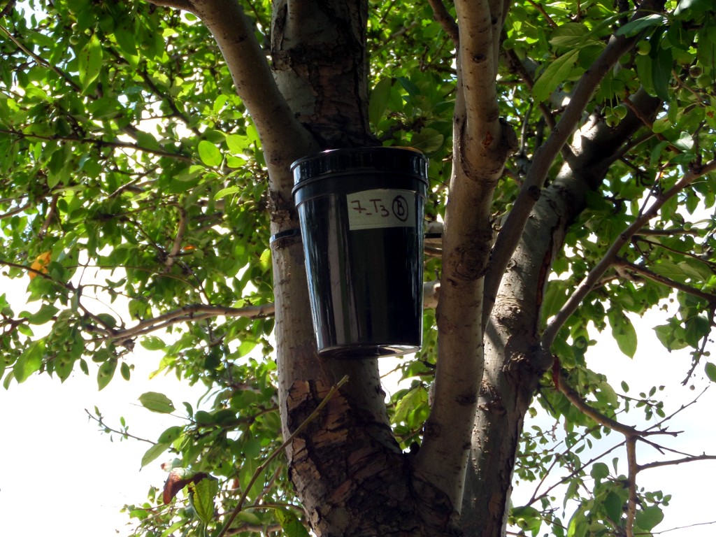
The objective of this project is to determine what spatial factors predict the distribution and abundance of mosquito species in Bloomington-Normal, Illinois. Species distribution maps will be produced for each species of mosquito that colonized oviposition traps (water-filled plastic cups lined with paper on which mosquito eggs are laid) placed on sampling transects during three sampling periods in August and September 2015. Poisson regression models will be used to produce maps predicting the occurrence of each mosquito species for the full 509 square kilometre study area.
Data:
+ 509 square kilometres of LiDAR data including Bloomington-Normal, Illinois, U.S.A. and surrounding areas with an average point density of 3.12 points/square metre classified into LAS Specification v1.2 codes: 1 (unclassified), 2 (ground), 7 (noise/low points), 9 (water), 10 (ignored ground: breakline proximity).
LAStools processing:
1) check the quality of the LiDAR data [lasoverlap, lascontrol, lasinfo, lasgrid]
2) merge and retile the original data [lastile]
3) classify point clouds into ground and non-ground [lasground]
4) create digital terrain (DTM) and digital surface models (DSM) [las2dem, blast2dem]
5) classify building and vegeration points [lasclassify]
6) extract building footprints [lasboundary]
7).produce height normalized tiles [lasheight]
8) generate a Canopy Height Model (CHM) with the workflow described here using the pit-free algorithm of Khosravipour et al. (2014) [lasthin, las2dem, lasgrid]
References:
Diuk-Wasser, M. A., Brown, H. E., Andreadis, T. G., Fish, D. 2006. Modeling the spatial distribution of mosquito vectors for West Nile virus in Connecticut, USA. Vector-Borne and Zoonotic Diseases 6: 283-295.
Dowling, Z., Ladeau, S. L., Armbruster, P., Biehler, D., Leisnham, P. T. 2013. Socioeconomic status affects mosquito (Diptera: Culicidae) larval habitat type availability and infestation level. Journal of Medical Entomology 50: 764-772.
Higa, Y., Yen, N. T., Kawada, H., Son, T. H., Hoa, N. T., Takagi, M. 2010. Geographic distribution of Aedes aegypti and Aedes albopictus collected from used tires in Vietnam. Journal of the American Mosquito Control Association 26: 1-9.
Khosravipour, A., Skidmore, A. K., Isenburg, M., Wang, T. J., Hussin, Y. A. 2014. Generating pit-free Canopy Height Models from Airborne LiDAR. Photogrammetric Engineering and Remote Sensing 80: 863-872.
Ruiz, M. O., Chaves, L. F., Hamer, G. L., Sun, T., Brown, W. M., Walker, E. D., Haramis, L., Goldberg, T. L. Kitron, U. D. 2010. Local impact of temperature and precipitation on West Nile virus infection in Culex species mosquitoes in northeast Illinois, USA. Parasites & vectors 3: 19.
Sun, X., Fu, S., Gong, Z., Ge, J., Meng, W., Feng, Y., Wang, J., Zhai, Y., Wang, H. H., Nasci, R. S., Tang, Q., Liang, G. 2009. Distribution of arboviruses and mosquitoes in Northwestern Yunnan Province, China. Vector-Borne and Zoonotic Diseases 9: 623-630.
USGS, HHS & CDC. 2015. Disease maps. http://diseasemaps.usgs.gov/mapviewer